
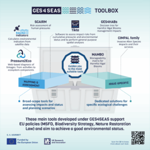
The GES4SEAS project has developed a comprehensive toolbox to support the achievement and management of Good Environmental Status (GES) in European seas. Marine ecosystems are subject to multiple, interacting pressures, and no single method can capture these dynamics or provide all the answers that managers need for effective decision-making.
The GES4SEAS toolbox provides practical, science-based instruments for assessing cumulative impacts, monitoring ecological components, and exploring management scenarios. Its goal is to help practitioners and decision-makers identify the most suitable approaches for their specific context, whether they are conducting Marine Strategy Framework Directive (MSFD) assessments, designing Marine Spatial Planning (MSP) measures, or evaluating risks from human activities, in Europe, and elsewhere
Why a toolbox with different tools?
The management of GES requires multiple perspectives. The GES4SEAS tools differ in:
- The type of input data they require (from qualitative expert judgment to spatial datasets).
- The outputs they generate (maps, decision trees, risk analyses, support for prioritisation of measures).
- The questions they address, from cumulative effects mapping, to environmental status assessment and ecosystem service linkages, all of them aim at improving policy guidance.
By bringing these tools together in one framework, GES4SEAS ensures that managers, scientists, and policymakers can select methods that best match their data availability, policy needs, and ecosystem context.
What tools are included?
The GES4SEAS toolbox includes:
- Decision-support systems for ecosystem-based management (SEAS4GES).
- Tools for cumulative effects assessment and mapping, such as Tikta, SCAIRM, Pressure2Eco, and EasySat Indicators, which go beyond ecosystem components and ecosystems and tackle ecosystem services.
- Tools for specific ecological challenges, such as harmful algal blooms (GES4HABs, MAMBO) or invasive alien species (CIMPAL family tools).
Each tool is designed to be policy-relevant, with clear links to the needs for implementing different directives, policies or strategies, such as the MSFD, EU Biodiversity Strategy 2030, and the Nature Restoration Law.
1. Tikta
Tikta
Tikta is a software to assess impact risks from cumulative pressures onto ecosystem components, environmental status and custom spatial and non-spatial analyses. It includes data/metadata management, a spatial analysis framework and visualization of results (maps and tables), all within a single environment. The software already includes implementations of these assessment methods: (1) CEA: Cumulative Effects Assessment; and (2) NEAT: Nested Environmental status Assessment Tool. More methods and more functionality will be available in Tikta in the near future.
The GES4SEAS CEA assessment tool integrated in Tikta performs assessments of risks coming from cumulative human activities and pressures on ecosystem components, by combining spatial data of these elements, together with sensitivity information of ecosystem components to pressures. The assessment is based on the method of Halpern et al. (2008, 2009).
The NEAT component integrated in Tikta performs environmental status assessments using indicator results applied to various level of spatial assessment units, habitats and ecosystem components. The assessment aggregates this information at different thematic and spatial levels (e.g. the Marine Reporting Units of the MSFD, or the subregional or regional level). The tool is customizable to assess the environmental status of the seas with respect to different needs such as the MSFD.
Results:
After including spatial data (GIS layers) of pressures and ecosystem components in the GES4SEAS CEA assessment tool, it is possible to analyze the risks associated to cumulative pressures spatially, using different methods of aggregation. Outputs include GIS layers (geographical maps) visualizing the risk of cumulative pressures affecting ecosystem components.
Regarding the NEAT component in Tikta, after including indicator values and their association to spatial assessment units, habitats and ecosystem components, as well as the spatial data for the assessment units (a GIS layer), the tool allows to performing an environmental status assessment for the defined study area, using different levels of aggregation. This system can ultimately be used to produce assessments following the MSFD guidelines for each MSFD descriptor. The outputs help understanding how the various ecosystem components and habitats in the assessment units contribute to the overall status. This can be used for defining measures to maintain or achieve a good environmental status.
Users & policy relevance:
Tikta is mainly targeted at scientists and technical experts with knowledge of the raw data and especially spatial data, but outputs are to be used by managers, decision-makers and stakeholders. As soon as all data are included and the analyses in Tikta are set up, managers can use the software to view the results and do scenario testing. Tikta is not bound to a specific kind of policy framework. It can be used flexibly but explicitly supports MSFD assessments, as well as the EU Biodiversity Strategy and Nature Restoration Law, and it can also work with other directives, such as the Water Framework Directive, Habitats Directive, among others.
Novelty & added value:
Tikta integrates all steps of the CEA and NEAT workflow – from data management and analysis to visualisation – ultimately supporting the MSFD guidelines to report the environmental status, within a single environment. It uniquely enforces metadata use and offers flexibility for customization and programmability, reducing reliance on multiple external software packages.
Link to resources
Tikta is still a semi-public tool, that is being used in training sessions with end users for MSFD, HD or RSCs reporting. The software will be fully available towards the end of the project.
https://www.ges4seas.eu/announcing-a-new-version-of-the-ges4seas-toolbox/
2. SEAS4GES
SEAS4GES. Selection of Ecosystem-based Approaches for Good Environmental Status
SEAS4GES is a decision-support tool that helps users identify the most appropriate Ecosystem-Based Management (EBM) approach for their specific needs and data context. It builds on a structured library of 35 existing EBM tools reviewed in GES4SEAS.
Results:
After responding to a series of 14 interactive, structure questions, the tool provides a ranked list of EBM tools matched to the user’s requirements and resources. Outputs include a detailed suitability matrix and an ordered list, showing which tools are most appropriate given the user’s goals, data availability, and expertise.
Users & policy relevance:
SEAS4GES can be used by scientists, consultants, and managers working with EBM in the context of EU marine policy. While originally designed with the MSFD in mind, it is equally useful for a broad range of ecosystem-based assessments and planning initiatives.
Novelty & added value:
SEAS4GES is the first structured framework that guides practitioners in selecting the most suitable EBM tools. By comparing tools objectively and systematically, it avoids a one-size-fits-all approach and helps users combine complementary methods to achieve robust management outcomes.
Link to resources
Tool: https://zenodo.org/records/14765920
Factsheet: https://zenodo.org/records/14760470
3. Pressure2Eco
Pressure2Eco. Pathway Explorer
Pressure2Eco is a web-based application that explores linkages between human activities, pressures, and ecosystem components in cumulative effects assessments.
Results:
The tool provides visual diagnostics (chord diagrams, Sankey plots, hierarchical tables), spatial maps, and gap analyses highlighting where key linkages or data are missing. It also generates recommendations based on data gaps.
Users & policy relevance:
Pressure2Eco can be easily applied with no scientific expertise and serves marine spatial planners, environmental managers, and researchers conducting CEAs, EIAs, or MSP. It supports MSFD implementation (Article 8 linkages) and it complements frameworks such as HELCOM, ODEMM, and SCAIRM for ecosystem-based management.
Novelty & added value:
The tool harmonises multiple linkage frameworks in a single platform and offers user-friendly diagnostics before carrying out a full CEA, EIAs, or MSP. It includes a specific framework derived from MSFD most recent guidelines documents. It streamlines workflows that previously required multiple tools, spreadsheets, and GIS packages. It provides web-based rasterization of user layers without software installation.
Link to resources
Information to be available soon
4. SCAIRM
SCAIRM. Spatial Cumulative Assessment of Impact Risk for Management
SCAIRM is a risk-based framework for evaluating the cumulative impacts of human activities on marine ecosystems and ecosystem services. It can integrate both qualitative (expert-based) and quantitative (spatial, magnitude–effect) information.
Results:
SCAIRM identifies the main anthropogenic threats, evaluates alternative planning scenarios, and evaluates ecosystem-based assessment management plans.
Users & policy relevance:
The tool is intended to be used by scientists and the outputs useful for decision-makers and planners engaged in MSP, Strategic Environmental Assessment (SEA), and EBM. Its outputs directly support the MSFD, the MSP Directive, and the Nature Restoration Law.
Novelty & added value:
Compared to existing CIA frameworks (e.g. Bow-Tie, ODEMM, Halpern-type approaches), SCAIRM provides more advanced and flexible risk calculations. It offers an integrated and quantitative way to evaluate risks.
Link to resources
https://zenodo.org/records/10159691
5. GES4HABs
GES4HABs. Harmful Algal Blooms Decision Tree
GES4HABs is a decision-support tool designed to guide policy makers and managers in addressing harmful algal blooms (HABs) within MSFD assessments. It builds on existing monitoring data and HABs’ event records in Marine Reporting Units.
Results:
The tool generates a decision tree that identifies management pathways based on the state and causes of HABs, helping to prioritise resource allocation and mitigation strategies.
Users & policy relevance:
The primary users are scientists and technicians, and the outputs useful for policy makers, environmental managers, and MSFD stakeholders. The tool supports the inclusion of HABs in GES assessments, helping to meet EU obligations for descriptor-based reporting and management.
Novelty & added value:
Despite their ecological and socio-economic importance, HABs have so far been underrepresented in MSFD reporting. GES4HABs introduces a systematic way to integrate HABs into marine assessments, filling a critical policy and management gap, especially in the context of climate change.
Link to resources
https://zenodo.org/records/10409030
6. MAMBO
MAMBO. Environmental Matrix for the Management of Blooms
MAMBO proposes to address the “manageability” of harmful algal blooms and their interaction with human and environmental pressures through a two-axis framework: trophic status of waters and anthropogenic influence.
Results:
The tool classifies HAB events into categories that determine whether they are likely manageable through intervention or primarily driven by natural conditions. It provides guidance on whether to apply Article 8 assessments, consider Article 14 exceptions, or carry out further monitoring.
Users & policy relevance:
MAMBO is to be used by scientists and technicians, and the outputs useful for policy makers and managers implementing the MSFD. It helps them decide when HABs can be managed through targeted measures, and when exceptions or further investigation are more appropriate.
Novelty & added value:
MAMBO introduces a pragmatic, evidence-based way to distinguish between HABs that are manageable and those that are not. It ensures management resources are used effectively and in compliance with MSFD obligations.
Link to resources
https://zenodo.org/records/10409030
7. CIMPAL family
CIMPAL family tools. Cumulative Impacts of Invasive Allien Species and HABs
The CIMPAL family of tools quantifies the cumulative impacts of invasive alien species (IAS), jellyfish blooms, and HABs on marine habitats and ecosystem services. Tools in this family include CIMPAL (negative IAS impacts), CIMPAL+ (positive impacts of IAS ), CIMPAL-JH (including of IAS, jellyfish and HABs), and CIMPAL-ES+ (positive IAS impacts on ecosystem services).
Results:
CIMPAL tools generate high-resolution maps of cumulative impact scores, rankings of species by their ecological or ecosystem service impacts, and recommendations for priority sites and species requiring management.
Users & policy relevance:
These tools are designed to be used by scientists and technicians, and the results useful for policy makers, competent authorities, and the Regional Sea Conventions. They support MSFD Descriptor 2 on IAS, the EU Biodiversity Strategy 2030, and reporting under the Kunming–Montreal GBF Target 6, among others.
Novelty & added value:
The CIMPAL suite goes beyond traditional IAS assessments by incorporating positive and negative impacts, multiple species interactions, and ecosystem service dimensions. It delivers reproducible, multi-scale workflows and fine-resolution (≤1 km²) hotspot maps directly usable for policy and spatial planning.
Link to resources
https://zenodo.org/records/16082826
8. EasySat Indicators
EasySat Indicators
EasySat Indicators is a tool that helps non-expert users to work with satellite data stored in NetCDF format, following the CF standard. It simplifies the process of calculating marine environmental indicators and exporting results in user-friendly formats.
Results:
EasySat Indicators offers two types of calculations:
- Pixel-based statistics to generate marine indicator maps.
- Location-based statistics (e.g., marine monitoring stations, or areas).
The available statistic metrics include mean, minima, maxima, count, median, 90th percentile (e.g. to be used in assessing the status under the Water Framework Directive) and the Mann-Kendall trend’s tau value. In all cases NA values are discarded. Results can be downloaded as GeoTIFF and CSV files for further analysis in Excel, GIS and in other tools developed by GES4SEAS.
Users & policy relevance:
The outputs can be utilised for various applications, either directly or as inputs in other developed GES4SEAS tools, namely in Tikta, for the assessment of the ecological status of marine waters, e.g. within the European Water Framework Directive (WFD) or the Marine Strategy Framework Directive (MSFD).
Novelty & added value:
This tool simplifies the process of calculating environmental indicators from satellite data sources and exporting results in user-friendly formats.
Link to resources:
Information about the tool (click here) and link to the tool (click here).